


MapPad GPS Land Surveys

MapPad GPS Land Surveys ਦਾ ਵੇਰਵਾ
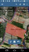
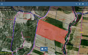
ਖੇਤਰਾਂ, ਘੇਰੇ ਅਤੇ ਦੂਰੀਆਂ ਦੀ ਗਣਨਾ ਕਰਨ ਲਈ ਅਤੇ ਮਾਪਾਂ ਨੂੰ ਬਚਾਉਣ, ਨਿਰਯਾਤ ਕਰਨ ਜਾਂ ਸਾਂਝਾ ਕਰਨ ਲਈ ਮੈਪਪੈਡ ਦੀ ਵਰਤੋਂ ਕਰੋ.
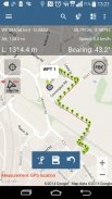
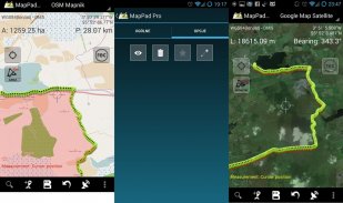
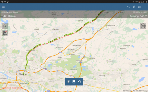
ਮੈਪਪੈਡ ਬਹੁ-ਉਦੇਸ਼ ਵਾਲੀ ਮੈਪਿੰਗ ਹੱਲ ਪ੍ਰਦਾਨ ਕਰ ਰਿਹਾ ਹੈ ਜਿਸ ਨਾਲ ਸਥਾਨ ਕੈਪਚਰ ਹੋ ਸਕਦਾ ਹੈ ਅਤੇ ਨਕਸ਼ੇ 'ਤੇ ਖਿੱਚੀਆਂ ਗਈਆਂ ਸ਼ੈਲੀਆਂ ਲਈ ਦੂਰੀ ਅਤੇ ਖੇਤਰ ਨਿਰਧਾਰਤ ਕੀਤਾ ਜਾਂਦਾ ਹੈ ਜਾਂ ਰੀਅਲ-ਟਾਈਮ ਜੀਪੀਐਸ ਟਰੈਕਿੰਗ ਦੀ ਵਰਤੋਂ ਕਰਕੇ ਕੈਪਚਰ ਕੀਤਾ ਜਾਂਦਾ ਹੈ.
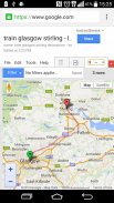
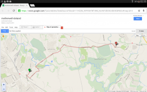
ਗੂਗਲ ਜਾਂ ਬਿੰਗ ਮੈਪ ਸੈਟੇਲਾਈਟ ਦ੍ਰਿਸ਼ ਦੀ ਵਰਤੋਂ ਕਰਦਿਆਂ ਤੁਰੰਤ ਖੇਤਰ ਦੇ ਖੇਤਰ ਜਾਂ ਤੁਰਨ ਦੀ ਦੂਰੀ ਦੀ ਗਣਨਾ ਕਰੋ. ਪੈਟਰੋਲ ਅਤੇ ਸਮੇਂ ਦੀ ਬਚਤ ਕਰੋ ਅਤੇ ਨਕਸ਼ੇ 'ਤੇ ਕੁਝ ਕਲਿਕਸ ਨਾਲ ਵਿਸ਼ੇਸ਼ਤਾਵਾਂ ਨੂੰ ਕੈਪਚਰ ਕਰੋ.
ਮੈਪਪੈਡ ਨਾਲ ਤੁਸੀਂ ਆਸਾਨੀ ਨਾਲ ਆਪਣੇ ਡਾਟੇ ਨੂੰ ਕੈਪਚਰ, ਪ੍ਰਬੰਧਿਤ ਅਤੇ ਸਾਂਝਾ ਕਰ ਸਕਦੇ ਹੋ.
ਜੰਗਲਾਤ, ਖੇਤੀਬਾੜੀ, ਇੰਜੀਨੀਅਰਿੰਗ ਅਤੇ ਰੀਅਲ ਅਸਟੇਟ ਪ੍ਰਬੰਧਨ ਵਿੱਚ ਸ਼ਾਮਲ ਕਿਸੇ ਵੀ ਵਿਅਕਤੀ ਲਈ ਮੈਪਪੈਡ ਇੱਕ ਬਹੁਤ ਹੀ ਲਾਭਦਾਇਕ ਸਾਧਨ ਹੈ.
Offlineਫਲਾਈਨ ਨਕਸ਼ੇ ਨੂੰ ਕਿਵੇਂ ਤਿਆਰ ਕਰਨਾ ਹੈ ਅਤੇ ਇਸ ਉਤਪਾਦ ਬਾਰੇ ਵਧੇਰੇ ਜਾਣਕਾਰੀ ਪ੍ਰਾਪਤ ਕਰਨ ਲਈ ਕਿਰਪਾ ਕਰਕੇ ਸਾਡੀ ਵੈਬਸਾਈਟ ਤੇ ਜਾਓ.
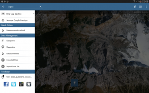
ਚੁਣੀਆਂ ਹੋਈਆਂ ਵਿਸ਼ੇਸ਼ਤਾਵਾਂ:
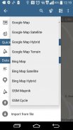
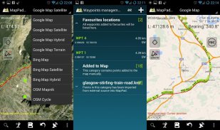
- ਅਧਾਰ ਨਕਸ਼ੇ: ਗੂਗਲ ਨਕਸ਼ੇ, ਖੁੱਲੀ ਸਟਰੀਟ ਦਾ ਨਕਸ਼ਾ, ਬਿੰਗ ਨਕਸ਼ੇ
- ਗੂਗਲ ਮੈਪਸ ਓਵਰਲੇਜ (ਕਸਟਮ ਡਬਲਯੂਐਮਐਸ ਜਾਂ ਆਰਕਜੀਆਈਐਸ ਸਰਵਰ ਟਾਈਲਡ ਸਰਵਿਸ), ਯੂਐਸ ਟਾਪੋਗ੍ਰਾਫਿਕ ਮੈਪ ਵਰਗੀਆਂ ਕੁਝ ਪਰਤਾਂ ਪਹਿਲਾਂ ਪਰਿਭਾਸ਼ਤ ਕੀਤੀਆਂ ਗਈਆਂ ਹਨ.
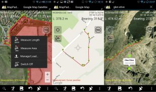
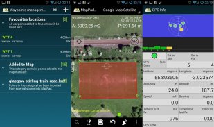
- ਖੇਤਰਾਂ ਅਤੇ ਦੂਰੀਆਂ ਦਾ ਬਹੁਤ ਸਹੀ ਮਾਪ.
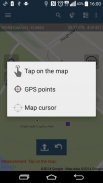
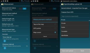
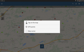
- ਮਾਪਣ ਦੇ 3 supportedੰਗ ਸਹਿਯੋਗੀ ਹਨ (ਨਕਸ਼ੇ 'ਤੇ ਟੈਪ ਕਰੋ, ਜੀਪੀਐਸ ਸਥਾਨ, ਨਕਸ਼ਾ ਕਰਸਰ ਸਥਾਨ).
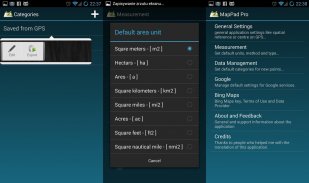
- ਮੈਟ੍ਰਿਕ ਅਤੇ ਸ਼ਾਹੀ ਇਕਾਈਆਂ ਦੀ ਗਿਣਤੀ ਲਈ ਸਹਾਇਤਾ.
- ਕਈ ਗਲੋਬਲ ਅਤੇ ਸਥਾਨਕ ਕੋਆਰਡੀਨੇਟ ਪ੍ਰਣਾਲੀਆਂ ਲਈ ਸਹਾਇਤਾ, ਜੇ ਤੁਹਾਨੂੰ ਕਿਸੇ ਹੋਰ ਸਥਾਨਿਕ ਸੰਦਰਭ ਲਈ ਸਹਾਇਤਾ ਦੀ ਜ਼ਰੂਰਤ ਹੈ ਤਾਂ ਕਿਰਪਾ ਕਰਕੇ ਸੰਪਰਕ ਕਰੋ.
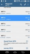
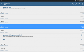
- ਵੇਅਪੁਆਇੰਟ ਨੂੰ ਹਾਸਲ ਕਰਨ ਅਤੇ ਉਹਨਾਂ ਨੂੰ ਸ਼੍ਰੇਣੀਆਂ ਵਿਚ ਸਮੂਹ ਕਰਨ ਦੀ ਸੰਭਾਵਨਾ.
- ਹਰੇਕ ਦਰਜ ਕੀਤੇ ਮਾਪ ਅਤੇ ਵੇਪ ਪੁਆਇੰਟ ਲਈ ਸਿਰਲੇਖ ਅਤੇ ਵਰਣਨ ਸ਼ਾਮਲ ਕਰਨ ਜਾਂ ਸੰਪਾਦਿਤ ਕਰਨ ਦੀ ਸੰਭਾਵਨਾ.
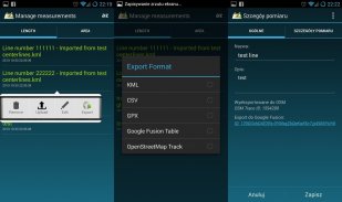
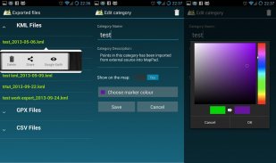
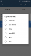
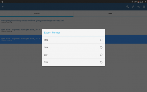
- ਐਸਐਚਪੀ ਫਾਈਲ, ਜੀਓਸਨ, ਆਰਕਜੀਆਈਐਸ ਜੇਸਨ, ਕੇਐਮਐਲ, ਜੀਪੀਐਕਸ, ਸੀਐਸਵੀ ਅਤੇ ਡੀਐਕਸਐਫ ਨੂੰ ਐਸ ਡੀ ਕਾਰਡ ਜਾਂ ਕਲਾਉਡ ਸੇਵਾਵਾਂ ਲਾਸ ਵਿਚ ਐਕਸਪੋਰਟ ਸਿੰਗਲ ਜਾਂ ਮਲਟੀਪਲ ਮਾਪਾਂ ਜਾਂ ਵੇਅ ਪੁਆਇੰਟਸ ਦੇ ਨਾਲ ਨਾਲ ਓਪਨ ਸਟ੍ਰੀਟ ਮੈਪ ਵਿਚ ਸਿੱਧੇ ਨਿਰਯਾਤ ਕਰੋ.
- ਸਿੰਗਲ ਵੇਪਪੁਆਇੰਟ ਸਥਿਤੀ ਸਿੱਧੇ ਐਸ ਐਮ ਐਸ, ਈ-ਮੇਲ ਜਾਂ ਹੋਰ ਤਰੀਕਿਆਂ ਨਾਲ ਸਾਂਝਾ ਕਰੋ.
- ਜੀਪੀਐਸ ਦੁਆਰਾ ਕੀਤੇ ਮਾਪਾਂ ਲਈ ਉੱਚਾਈ ਪ੍ਰੋਫਾਈਲ ਉਪਲਬਧ ਹੈ.
- ਐਪਲੀਕੇਸ਼ਨ ਨੂੰ ਕੇਐਮਐਲ ਅਤੇ ਜੀਪੀਐਕਸ ਫਾਈਲਾਂ ਦਾ ਆਯਾਤ.
- ਜੀਪੀਐਸ ਸਥਿਤੀ ਅਤੇ ਉਪਗ੍ਰਹਿ ਦੀ ਸਥਿਤੀ.
- ਪਤਾ, ਸਥਾਨ ਦੀ ਖੋਜ.
- ਗੂਗਲ ਅਰਥ ਵਿੱਚ ਤੇਜ਼ੀ ਨਾਲ ਖਰੀਦੀ ਗਈ KML ਫਾਈਲਾਂ
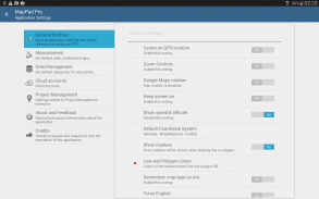
- ਡਿਫੌਲਟ ਮਾਪ ਮਾਪ, ਇਕਾਈਆਂ ਨੂੰ ਨਿਰਧਾਰਤ ਕਰਨ ਦੀ ਯੋਗਤਾ, ਵੇਪ ਪੁਆਇੰਟ ਦੀਆਂ ਸ਼੍ਰੇਣੀਆਂ ਦੇ ਰੰਗ, ਟਰੈਕ ਰਿਕਾਰਡਿੰਗ ਸਮਾਂ ਅਤੇ ਦੂਰੀ ਦੇ ਅੰਤਰਾਲ, ਗੂਗਲ ਨਕਸ਼ੇ ਦੀ ਓਵਰਲੇਅ ਦੀ ਪਾਰਦਰਸ਼ਤਾ ਅਤੇ ਹੋਰ ਬਹੁਤ ਕੁਝ ...
ਸਾਡੇ ਉਪਭੋਗਤਾ ਸਫਲਤਾਪੂਰਵਕ ਪ੍ਰੋਜੈਕਟਾਂ ਅਤੇ ਐਪਲੀਕੇਸ਼ਨਾਂ ਦੀ ਗਿਣਤੀ ਵਿੱਚ ਮੈਪਪੈਡ ਦੀ ਵਰਤੋਂ ਕਰ ਰਹੇ ਹਨ.
MapPad GPS Land Surveys - ਵਰਜਨ 7.5.0
(19-05-2019)
MapPad GPS Land Surveys - ਏਪੀਕੇ ਜਾਣਕਾਰੀ
ਏਪੀਕੇ ਵਰਜਨ: 7.5.0ਪੈਕੇਜ: com.osedok.mappadMapPad GPS Land Surveys ਦਾ ਨਵਾਂ ਵਰਜਨ
ਹੋਰ ਵਰਜਨ


ਇੱਕੋ ਸ਼੍ਰੇਣੀ ਵਾਲਿਆਂ ਐਪਾਂ

ਤੁਹਾਨੂੰ ਇਹ ਵੀ ਪਸੰਦ ਹੋ ਸਕਦਾ ਹੈ...


